
Spring-like Through Friday, Then Winter Returns
Columbia – Welcome to South Carolina, where you can enjoy your favorite parts of each season over the course of five days!
It’s an exaggeration to say it’s feeling like summer now, but temperatures were well into the 70s over nearly the whole state Wednesday, and Thursday is looking even warmer. That’s undoubtedly spring like and the risk of severe storms over a part of the state coming up Friday adds to the spring like feel.
A cold front will slowly cross the state Thursday night into Friday, which will bring wet weather to all of the state with the potential for embedded thunderstorms.
Behind the front, colder air will settle in (here’s a few hours of fall during the transition), ushering in a return of winter with below-average temperatures for the weekend. Meanwhile, a storm system moving through the Northwest today will follow a path that brings it into our neck of the woods on Sunday. The computer models are in generally agree that low pressure will form over the northeastern Gulf of Mexico or Florida later Saturday and track northeastward along the Carolina coastline through Sunday. Such storm tracks this time of year are the ones that sometimes produce a white coating over some or all of the Palmetto State.
The problem is that temperatures will barely be cold enough this weekend to worry about a winter storm. Our current weather pattern favors more warm days than cold ones and the colder ones aren’t all that cold. It just happens that this weekend’s storm will hit during one of the brief cold snaps that we’re bound to get this time of year, even in a weather pattern that’s warm overall. If we get snow out of this setup, it’s like an angler foul-hooking a fish (where you catch the fish with the hook stuck in something other than the fish’s mouth).
There are too many variables at this point to say how much of the state might see snow and how much snow will fall. Of course, the northern half of the state, particularly the Upstate, has the best odds for seeing snowflakes instead of raindrops for a time and the chances for snow are lowest along the Coastal Plain and near zero in the Lowcountry. However, even in the I-85 corridor, temperatures likely remain above freezing, limiting the chances for accumulation. Timing will also be a big question. If it does end up snowing, it could happen during the daytime, making it even more difficult to get the snow to stick.
The list of things we know right now is short:
- Saturday looks cold and rainy but not cold enough for snow.
- Saturday night through Sunday morning is the most likely time for the snow, when the heaviest precipitation will occur and when it will be coldest.
- The situation favors either rain or snow, with freezing rain and ice accretion unlikely.
- The best chances for accumulating (and potentially heavy) snow will be in the mountains above 2,000 feet, thus mostly in North Carolina.
- Rainfall will be substantial from this storm, as computer models call for a general 1-2 inches over the weekend, on top of a possible 1-2 inches falling Thursday into Friday.
- The moon is not in a full or new moon phase, so low astronomical tides will occur, limiting the risk of coastal flooding from this weekend’s storm.
- The forecast will change as we get closer to the event. The current computer model consensus is for nothing more than a small, slushy accumulation mainly confined to the Upstate, but both a noteworthy snowstorm for a part of the state and only cold rain statewide are currently reasonable possibilities.
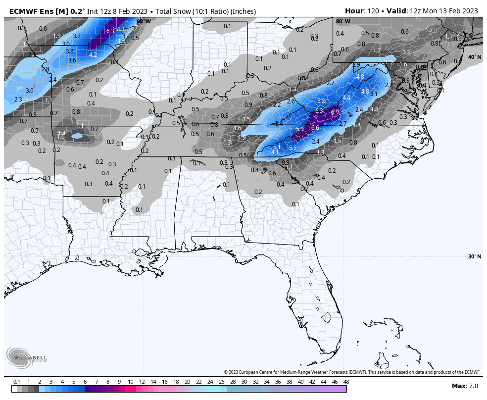
The ECMWF EPS (the Euro ensemble model) ensemble mean total snowfall through Monday morning, from the run initialized at 1200 UTC (7:00 a.m. EST) Friday. This model usually has the best handle on the longer range and I think it has the best chance to be correct on the snowfall forecast this weekend.
The bottom line here is that you don’t need to plan a bread-and-milk run just yet. Let’s keep the demand for that stuff low right now. Eggs are expensive enough; we don’t need a price shock from high demand for any other staples. I’ll bring you daily updates as we get closer to the event.
Frank Strait
Severe Weather Liaison
S.C. State Climate Office
S.C. Department of Natural Resources